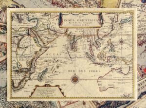
Homepage » China
  • Instructions:
    • Selecting a value changes the state (0) to the actual state.
    • Combine multiple terms for more precise results.
    • Available options have a state greater than (0).
    • If the state remains (0), reduce the number of selected options.
    • Products often have variations – open “Select options” to view them.
    • The image and price may change based on selected options.
    • To search, select “Apply”.
  • Clear all filters
  • According to cartographic categories:

  • Clear all filters
  • Stara karta, Indian Ocean (N-31)

    Indian Ocean (N-31)

    15,92

    Map of the Indian Ocean, Pierre Duval, Antwerp 1665 is supplied with a cardboard sleeve which is included in the price on the web shop.

    Select optionsLoading Done This product has multiple variants. The options may be chosen on the product page Quick view
  • Stara karta, Indonesia (N-32)

    Indonesia (N-32)

    15,92

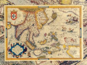
    Ortelius, 1570, Map of Indonesia, including India, New Guinea, China and the Northwest Coast of America, is considered the first modern atlas. it is delivered with a cardboard sleeve which is included in the price on the web shop.

    Select optionsLoading Done This product has multiple variants. The options may be chosen on the product page Quick view
Firmus grupa d.o.o.
Emila Antica 53
51266 Selce
Croatia
OIB: 65092215454
VIES: HR65092215454
PRIVREDNA BANKA ZAGREB
IBAN: HR40 234 0009 111 0643 883
SWIFT: HAABHR22

Final recipient of a financial instrument co-financed by the European Regional Development Fund under the Operational Programme “Competitiveness and Cohesion”.

Replicas of old maps
Privacy Overview

This website uses cookies so that we can provide you with the best user experience possible. Cookie information is stored in your browser and performs functions such as recognising you when you return to our website and helping our team to understand which sections of the website you find most interesting and useful.